Lytx Unified Map
Enhancing Fleet Safety with Real-Time, AI-Powered Road Insights

Unified Map reimagined how safety managers monitor severe weather risks.
By combining AI with real-time road data in a unified map interface, customers can identify environmental hazards faster and respond with greater confidence.
Today it is a core Lytx capability driving retention and expansion.
Overview
Role
Senior Product Designer
Timeline
Jan’ 2023 - Sept’ 2023
Challenges
Fleet managers need to make quick, high-stakes decisions during fast-changing weather conditions—but today’s their tools slow them down.
Fleet managers may have access to plenty of data, but it’s scattered across fragmented weather reports, outdated systems, and manual processes.
The result? Delayed response times, missed hazards, and increased risk on the road. Every year, over a million crashes are tied to weather; fleet safety teams deserve better tools to respond in real time.

“We don’t have time to piece together weather information from five different sources—by the time we do, the road conditions could already have changed.”
-Safety Manager, Enterprise Trucking Company
Discovery
To understand why fleet managers struggled with weather-related decisions — and why outdated tools were still heavily used — I conducted:
User Interviews → Spoke with fleet safety managers and operations teams to uncover their current workflows and pain points.
Onsite Observation → Observed how fleet teams communicated weather disruptions during an onsite visit—uncovering offline workarounds like physical billboards that highlighted gaps in our digital experience.
Usage Analysis → Analyzed patterns from an outdated feature related to real-time access to road images and found surprisingly high engagement, pointing to overlooked needs.
Competitive Analysis → Evaluated existing weather and fleet tracking tools to understand the market landscape.

Key Insights
Today’s workflows are time-consuming and make it hard for fleet managers to quickly assess and respond to changing road conditions.
1️⃣ Fleet managers often juggle multiple disconnected tools just to figure out how the weather might impact their fleet.
It slows them down and adds extra work they shouldn’t have to do.
“I have to check at least 3 to 5 different platforms just to understand the weather’s impact on our fleet —it’s time-consuming and frustrating. Each state also has its 511 platform. If you add those too, that’s even more…”

2️⃣ Weather data is usually too broad or generic.
While alerts might cover an entire region, managers still have to figure out how it impacts specific routes or drivers — leaving them uncertain about what’s really happening on the roads that matter most.
“Even when I see a weather warning, I don’t know how severely the roads are impacted. They are just forecasts. We would have to make a lot of guesses.”

3️⃣ Without visuals, everyone forms a different picture of the situation, making alignment harder.
Managers often pull screenshots from 511 platforms or weather sites to piece things together. But without a shared, concrete view, people interpret road conditions and risks differently, which slows down alignment and decision-making.
“Seeing the actual image removes all the doubt away, suddenly everyone is on the same page.”

Guiding
Principles
Based on the research insights, I defined key principles to guide my design decisions.
These principles grounded my design approach and helped inform my engineering partners on what truly mattered to users. They kept our team focused on building a tool that helps managers make faster, more confident decisions.
Information should come together, not live across fragmented tools.
We should reduce the need for managers to jump between systems by bringing essential weather, road, and fleet data into one clear view
Timely information drives better decisions.
We should focus on surfacing the right information at the right moment — helping managers act before risks escalate.
Risks should be obvious, not hidden.
We should make risks immediately clear through visual cues. Our product should help users quickly grasp what's important without having to dig through layers of data or rely on subjective interpretations.
Solution
Unified Map is an AI-powered mapping tool that combines real-time road conditions, live camera images, and fleet location data into a single, intuitive interface.
AI-Powered Road Condition Detection
As we worked on the map, I noticed managers still had to manually scan camera feeds to identify whether a specific road is impacted by the weather. To address this, we came up with a new layer that leverages computer vision to detect and classify conditions like snow, rain, and fog in real time.
Now, those conditions are highlighted directly on the map, helping managers quickly see where weather may be a concern and decide if they need to take action.

Real Time Road Intelligence
Fleet managers used to see footage only from their own vehicles. Now, by tapping into Lytx’s full network, we surface live road images from any Lytx-equipped vehicle—instantly showing conditions in high-risk areas. To enhance the experience, we also selectively prefetch and auto-display only the most relevant views.
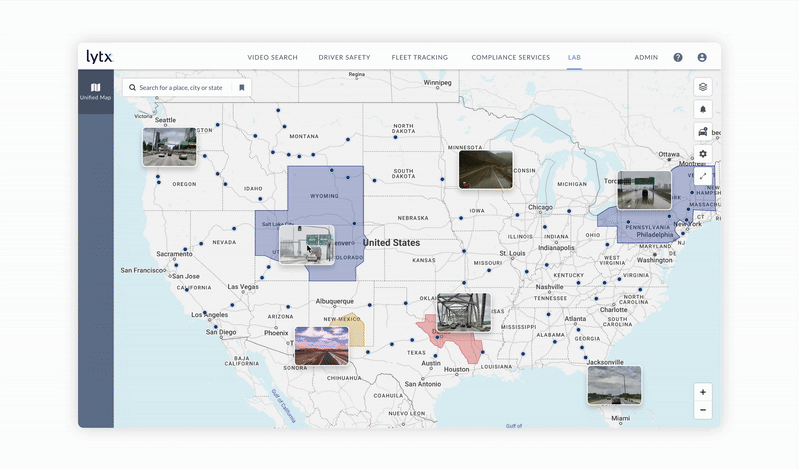
Multi-Layer Map Overlays
Previously, managers had to switch between tools to understand road conditions, vehicle locations, and alerts. Now, we let them layer AI-detected road conditions, fleet locations, traffic, and weather on a single map—giving safety and operations teams a complete, real-time view in one place.
But… we didn’t stop there.
Adoption was strong, but managers were still taking screenshots and manually warning drivers. The map showed risk—it didn’t yet help them act on it.
From Insight to Action
To address these gaps, we expanded our solution with new features that went beyond mapping to support managers throughout their workflow.
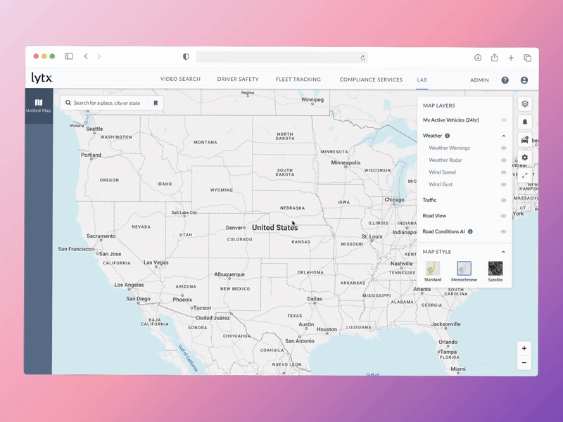
To eliminate the need for managers to constantly monitor the system, we built proactive email alerts for upcoming weather risks and geo-based driver warnings delivered directly to the vehicle.
These tools help managers stay ahead of changing conditions and ensure drivers receive timely, location-based warnings without relying on manual intervention.

Customer Impact
By providing automated alerting, centralized mapping, and real-time visibility to the road, we helped managers make faster decisions and keep their drivers safer.
These tools are now used by 20% of Lytx’s core product users.
Directly supports thousands of managers in monitoring and responding to weather risks.
Helping managers act faster and with more confidence by giving them clear, real-time weather insights they can trust.
“We used to spend hours digging into weather. Unified Map cut that time in half, and the automatic alerts make it easier to keep our drivers aware of hazards nearby.”
-Safety Manager, Enterprise Trucking Company
Business Impact
By addressing weather-related hazards, we unlocked a broader opportunity in situational risk management — expanding Lytx’s platform and strengthening its competitive edge.
Scaled Adoption and Revenue
Unified Map evolved from an experiment to a core offering, driving high user adoption, increasing revenue, and converting trial users into long-term customers.
Expanded Risk-Based Features
We delivered new risk-based features, including driver hazard alerts, automated weather notifications, and deeper analytics — allowing safety managers to respond faster and with more confidence.
Strengthened Strategic Positioning
This work also uncovered how situational risk could enhance coaching conversations, opening opportunities for Lytx to expand beyond driver behavior. It played a role in repositioning Lytx as a leader in proactive, risk-focused safety management.